As a result, it is exciting when we come across another bit for the historic record that sheds a bit of light on the forgotten era, when oysters were an abundant and freely available source of protein for all.
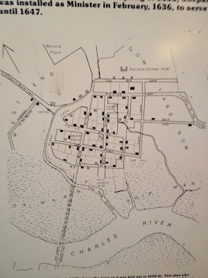
In Cambridge's Winthrop Square there is a Peet's Coffee cafe and immediately outside it a plaque discussing the settlement of Newtowne, which later grew into Harvard Square. It begins with a map of the area as it looked in Colonial times before there was extensive fill. On the map below you can see how the coast is uneven as winding tidal rivers ran through coastal marsh.Charlestown and Boston are still peninsulas and the Charles River Bay is significantly wider before it was filled extensively to make the land that now supports MIT and the Back Bay.
 |
| Dots on Map of early Cambridge lead to the location of Newtowne, which was centered on Winthrop Square. The dotted path on the river ends at this location. |
This map shows the settlement as it was in the 1600's with Harvard as a single building on top. But what is particularly interesting is the legend on the road leading to the right or Southeast on this map. We have highlighted it in the third picture below.
 |
| Map of early Cambridge Massachusetts with reference to the Oyster Bank |
The picture below shows an enlargement of the road. The legend reads Highway to the Oyster Bank. This is yet again another piece of history pointing to the large presence of oysters here in Colonial Times.
 |
| Cambridge Map close up of the Highway to the Oyster Bank. |

No comments:
Post a Comment